Mapping possibilities at Meyers High School
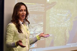 Meyers High School continues to map out new options for students, literally, adding the opportunity to work with a sophisticated, online Geographical Information System program. Students in Chris Sedon’s computer programming class got a glimpse of the possibilities Monday morning.
“What’s geography?” asked Daniel Yelito, sporting the fluorescent vest he wears in the field while hunting for uncharted bridges that have fallen off the radar of the Pennsylvania Department of Transportation. “It’s the world, and everything in it.”
To read the full article from the Times Leader, click here.
Posted: Tuesday, April 12, 2016